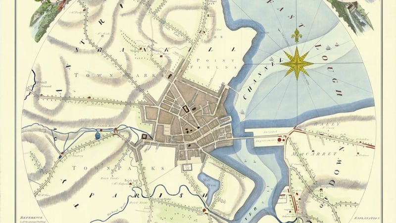
A rare map showing Belfast with a river running through High Street, which allowed ships to dock in the18th century city is to go on display in Linen Hall Library.
The map dated 1791 is among a number of items on display in the library's June exhibition.
It shows an unrecognisable city landscape with ships docked in High Street and water flowing through what are now many of the city's main thoroughfares.
Historian Dr Eamon Phoenix said it wasn't until 1850 that the river was widened to allow Belfast to become an industrial shipping port, until then boats would dock in High Street right up to where St George's Church now stands.

"This was the Belfast of the United Irishmen, founded in that year, who sought to unite Protestant, Catholic and Dissenter", said Dr Pheonix.
"A liberal golden age when the Presbyterians of the city built a chapel for the small Catholic population, only around six per cent that time, at Chapel Lane.
"The Farset River would have went from Bridge Street turning a hard left at the Northern Whig, it still runs underground.
"It wasn't until the 1850s when the channel was widened to become a proper port, the sludge scrapped from the lough was piled up into an artificial island, now known as Queen's Island.
"This allowed for Harland and Wolff shipyard to be founded in 1861".
Because of the river that once ran through the now busy shopping streets, Dr Phoenix says some interesting artefacts have been discovered over the years.
"At the turn of 20th century during building work in the area two skeletons were discovered, locked in mortal combat with a rusty dagger between them, it is thought they been fighting on board a ship docked in the area, fallen overboard and been preserved forever".
As well as the 1791 map of Belfast, Mapping Urban Ireland exhibition offers a window into the development of other Irish towns and cities.
The historic maps were produced for a variety of purposes, some had military or propaganda functions, while others were drawn to assist in planning the future development of towns.
Presented in association with the Royal Irish Academy, the Mapping Urban Ireland exhibition will run from June 5 until June 26, admission is free.
For more information please visit the Linen Hall Library website.