SOME 4,700 homes were still without power across Northern Ireland on Tuesday night with emergency teams assessing a 'major fault' in the Enniskillen area due to Storm Frank.
Earlier, 6,000 homes were without power. Northern Ireland Electricity said 1,300 customers had their supply restored in the Enniskillen area.
Belfast International Airport is disembarking passengers from nine aircraft as winds speeds reduce from 55 knots to 44 knots.
Flights from Edinburgh, Tenerife, Liverpool, Manchester, Birmingham, Newcastle, Glasgow, Gatwick and Bristol landed, but because of the high winds, it wasn’t immediately possible to manoeuvre aircraft access steps into place.

Two inbound flights, from Luton and Tenerife, diverted to Dublin.
The disruption will have a knock-on effect on scheduled departures to Gatwick, Glasgow, Bristol, Newcastle, Edinburgh, Liverpool and Manchester.
Earlier ground handling firm Swissport suspended operations as wind speeds exceed safety levels by some 7/10 knots.
A Belfast International Airport spokesperson said: “Airport staff and Swissport personnel are doing all they can to disembark passengers.
"We understand the frustration of passengers, and those waiting in Arrivals, but we must stress that the safety of passengers and our workers
is our top priority and ask for their continuing patience.
“The high wind warning lasts until the early hours of Wednesday morning. Some airlines have cancelled flights, so we would ask passengers to please contact their airline for updates.”
Three flights from London Heathrow to George Best Belfast City Airport have been cancelled tonight.
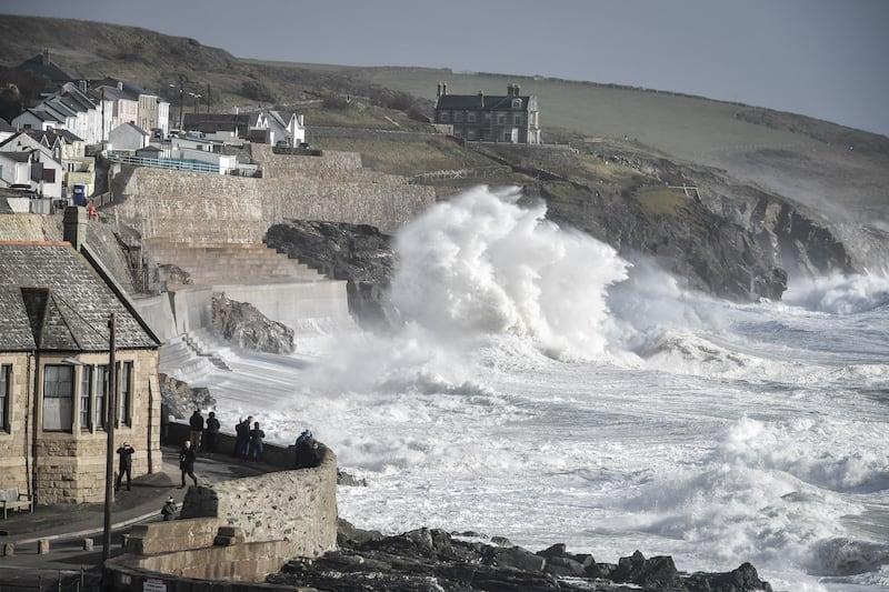
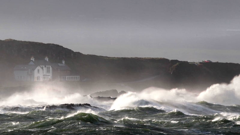
A weather warning for rain in Northern Ireland has been upgraded from yellow to amber, as heavy rain and gales are expected as a result of Storm Frank.
The Met Office has issued several severe weather warnings for the north over the coming days.
An amber warning of heavy rain is in place from 9pm Tuesday until 7am on Wednesday morning. The Met Office has warned people to be prepared for disruption causing by flooding from rivers and surface water on roads.
A slow-moving cold front will move across the north from tonight onwards into Wednesday morning. Rainfall accumulations of 20-4 mm and locally in excess of 60 mm are possible over the area marked by the amber warning. Further heavy showers will then follow during Wednesday daytime.
Strong winds are also to be expected from this afternoon until tomorrow morning. Gale force winds reaching speeds of 55-65 mph are likely across the country, with gusts possibly reaching 70-80 mph in exposed areas.
Strong winds and rain are expected to diminish, but continue, until the weekend before conditions become drier and brighter on Saturday.
We have a large fault in the #Enniskillen area. Our emergency crews are assessing damage. Updates to follow. #StormFrank #StaySafe
— NIE Networks (@NIElectricity) December 29, 2015
Email us your pics of Storm Frank like this one at Downhill, Co Derry to: digital.editorial@irishnews.com pic.twitter.com/3SSITQPhu6
— The Irish News (@irish_news) December 29, 2015
Didn't think much of #StormFrank until I saw what it was doing to the Glencar Waterfall. #defyinggravity pic.twitter.com/V5GULYtTpB
— Tracy (@tracyotoole1) December 29, 2015Continued caution urged as #StormFrank impacts across the county, with heavy rainfall & winds producing challenging driving conditions.
— GalwayCountyCouncil (@GalwayCoCo) December 29, 2015
@barrabest @AlanBrecknell @adorationsister @molloy1916 Epic gale, Newcastle, Co. Down. Gusts nearly knocked us over. pic.twitter.com/FkXr6lHLCY
— Anne Cadwallader (@AnneCadwallader) December 29, 2015