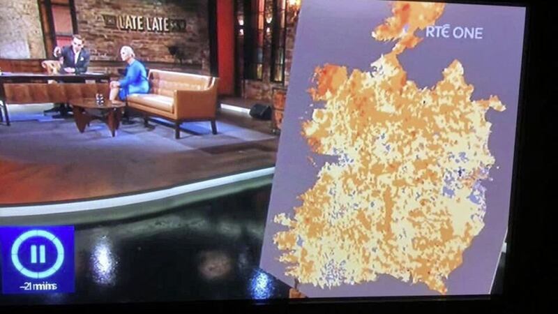
A SENIOR RTÉ executive has apologised for upsetting viewers after a map of Ireland was shown on `The Late Late Show' with "the north carved out".
The appearance of the map on the popular Friday evening chat show, which is watched widely in Northern Ireland, prompted a storm of criticism from nationalists on both sides of the border, as well as some more mocking comments on social media.
Among the joking suggestions were that the image represented an `after' picture following last month's serious flooding or a future Brexit hard border.
However, the level of outrage - prompting more than 200 formal complaints to the broadcaster - has led the show's executive producer John McMahon, to apologise for the "disrespectful and distressing" appearance of the map.


One of the letters of apology was sent to West Tyrone MP, Barry McElduff.
Mr McMahon wrote that he was "truly... sorry that you were unhappy with the presentation of the item on social inequality in Ireland... and particularly that the data map we used was the cause of upset to viewers".
He said the map, which was provided by a third party, "was not a geographical or political one, but a data map" with the blue in the map referring "to income status, not rivers or lakes as is normal".
The producer reiterated RTÉ's explanation that it was based on "research using data received from the Republic of Ireland census, and as such did not contain any data relating to the six counties and therefore that section of the map was blank".
Mr McMahon said the graphic was "important" to show areas across the 26 counties where "social inequality and deprivation are having a serious impact on the life and life expectancy of communities".
But he said: "I fully accept that as presented, the map appeared to many as a geographical map and as such appeared disrespectful and distressing to you and other viewers.
"All I can do is assure you that it was not an intentional slight on our audience north of the border and I apologise for the upset caused to viewers both there and in the Republic."
Mr McElduff said he "welcomes" the apology.
"The Late Late Show and RTÉ, the national broadcaster, are very important in the cultural life of Ireland - all parts of Ireland," he said.
"People are sick to their stomachs to see a map of Ireland with the north carved out.
"This definitely caused major upset and major offence and I can see why because it was awful.
"I want RTÉ to learn from this to treat respectfully and as equals people from the north who tune in and who view The Late Late Show and who listen to RTÉ radio."