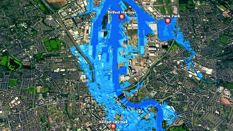
DETAILED new maps pinpoint the areas of Northern ire-land most at risk of flooding. Around 46,000 homes and other properties are vulnerable to water sweeping across floodplains, coastal and low-lying areas, according to the Rivers agency. And while some can call on measures such as flood walls or coastal sea defences, half are thought to have no protections in place. Areas including Belfast, derry, Newry, Omagh and Strabane are among 20 hotspots identified as having a 'significant flood risk'.
Researchers identified four 'spill areas' in Belfast that could be affected in the event of a tidal flood, which is said to occur once every 200 years. A further 49 locations such as dungannon, Maghera and Rostrevor were considered by experts as requiring "further investigation". The flood hazard and risk maps also show the infrastructure and other facilities that could be affected by flooding. It is hoped the extensive study will help businesses and homeowners assess their individual levels of risk and encourage communities to develop flood plans. Around £60 million of public funds are being spent each year protecting property against flooding, with water damage to a house costing an average of £20,000 to clean up.
Northern ireland has been affected by several severe floods in recent years. In august 2008 the north experienced one of its worst periods of flooding, causing rivers to burst their banks, landslides and roads to be cut off. The interactive maps, developed by Rivers agency, were launched yesterday by agriculture minister Michelle O'Neill. The Sinn Fein Mla for Mid Ulster said they are an "important visual tool in communicating the areas at risk".
"If you find that you live or work in an at-risk area, you should not ignore this information but plan for it, as recent events have shown the value of being flood-aware," the minister said.

"The information from these maps will also inform the work to produce Flood Risk Management Plans for areas at significant risk." The new maps, a requirement under the EU Floods directive, update the Strategic Flood Map by providing detailed information for most towns and cities.
Maps for a total of 69 areas were produced using the best available flood-modelling techniques, tools and data.
Ms O'Neill said: "i think it is very reassuring that these more detailed and refined maps, which have been produced by Rivers agency, will greatly enhance our understanding of the real threat we face from flooding.
"By using this information and working together we can hopeful-