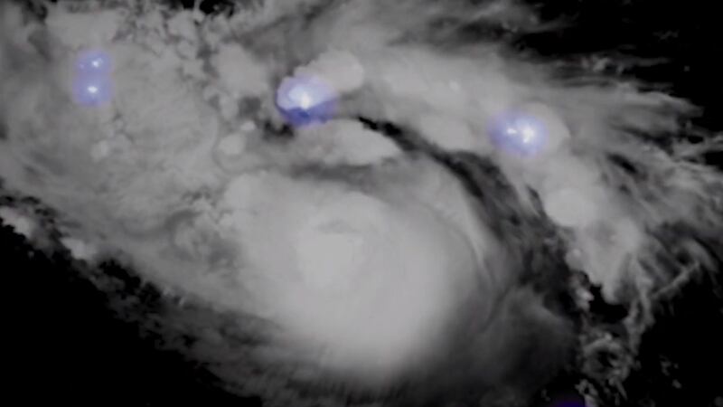
Hurricane Dorian’s immense power has been laid bare by spectacular moving satellite imagery.
Meteorologist Dakota Smith used images taken by the National Oceanic and Atmospheric Administration (NOAA)’s GOES-16 satellite, offering a view from above of the storm, which was recently upgraded to category 5.
Sunrise on Hurricane Dorian.
A Category 5 monster. pic.twitter.com/BzWcCRJFVa
— Dakota Smith (@weatherdak) September 1, 2019
Dorian is moving west and is expected to reach the Bahamas on Sunday.
The storm is bringing with it torrential rain and powerful winds, which the National Hurricane Centre in Miami say have increased to 160mph.


Hurricane Dorian putting on a lightning show tonight.
Spectacular imagery. pic.twitter.com/cdrs22PZqe
— Dakota Smith (@weatherdak) August 30, 2019
Mr Smith has carefully constructed the imagery from the GOES-16 satellite into GIFs and videos that have been shared tens of thousands of times on social media.
GOES-16 is a geostationary satellite with its gaze fixed upon the area to the east of the US and across South America.
The corresponding infrared imagery. Dorian's a beast.
Put together a bunch of imagery from today: https://t.co/XgvZrjGjDf pic.twitter.com/lbThakAV49
— Dakota Smith (@weatherdak) September 1, 2019
Many in the Bahamas have left their homes ahead of the storm’s arrival after the archipelago’s Prime Minister Hubert Minnis warned any “who do not evacuate are placing themselves in extreme danger and can expect a catastrophic consequence”.