THERE has been much comment in recent days about Van Morrison and how he weaves place names and the memories they evoke for him into his song lyrics.
Last week saw the 50th anniversary of the release of Astral Weeks which includes the epic and still hugely evocative track Cyprus Avenue, named after the street close to where Morrison grew up.
Van the Man-themed walking tours take visitors to Hyndford Street, Orangefield and ‘the Hollow’, which is mentioned in one of his best-known songs, Brown Eyed Girl.
The tours take place in east Belfast but you can also follow a ‘Van Trail’ in south Down, although a slightly meandering one, in his spoken prose poem Coney Island, from the album Avalon Sunset.


He name checks Downpatrick, St John’s Point, Killyleagh, Shrigley, Strangford Lough and ends up in Ardglass for some mussels and potted herring.
Along the way he badly mispronounces the word Lecale – but sure “the craic was good” – before reaching Coney Island, which lies just outside Ardglass and finishing with the line “wouldn’t it be great if it was like this all the time”.
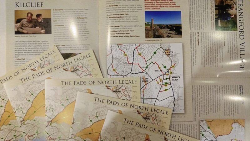
Which in a nicely convoluted journalistic way leads me to the newly published The Pads of North Lecale.
Being on my doorstep, this covers an area I walk regularly, but the information-packed publication brought home how much I have missed along the way.
Detailed maps of ‘rights of way’, known locally as ‘pads’, a history of the area, regional folklore and the origins of place names map out the terrain.
This is St Patrick’s Country and many of features are associated with the patron saint who is believed to have sailed up along Strangford Lough in 432AD and landed at the mouth of the Slaney River.
A chieftain gave him a barn to use as his first church – the Irish word for barn is Sabhall, which has been anglicised to give us the modern-day village and townland of Saul.
In recent years the area has become a popular tourism stop-off because of the numerous locations used to shoot scenes from Game of Thrones – busloads of people wearing capes and carrying fake swords descend each day to visit and walk the well-marked-out trails.
But as the authors of The Pads of North Lecale note, this area’s real history is "too scary for dragons”.
Celts, Gaelic chiefs, Vikings, Normans, Scots and English settlers have all made their mark on the region, giving it a rich cultural and historical texture. But this is just a backdrop to the main theme of this publication – using maps, pictures and words, it locates the public rights of way that weave through the drumlins, loughs, woodlands and hills to open up its hidden corners.
Insights from people who have lived all their lives in Lecale bring these places alive, with nuggets of folklore, the origins of place names and recollections of the people who lived there and the stories and legends that grew around them.
The publication also serves as a manifesto for public access to the countryside and a reminder of how the north’s district councils opened up miles of ‘pads’ which had traditionally been used by residents but which traversed private land.
There is also advice for walking in the countryside, respecting land boundaries and keeping to the ‘rights of way’ and ensuring that wildlife is not disturbed.
Written by Newry, Mourne and Down councillor Cadogan Enright and walking guide Duane Fitzsimmons, The Pads of North Lecale costs £3, with proceeds going to community projects.
Hopefully more publications will follow and it will serve as a useful template for other areas to produce similar guides.