THE place to be this weather if you're a walker and outdoor enthusiast is the newly opened Cuilcagh Mountain trail in Co Fermanagh. This impressive path goes to to the summit of the mountain from the car park at Legnabrocky about 1km from the road entrance to Marble Arch Caves.
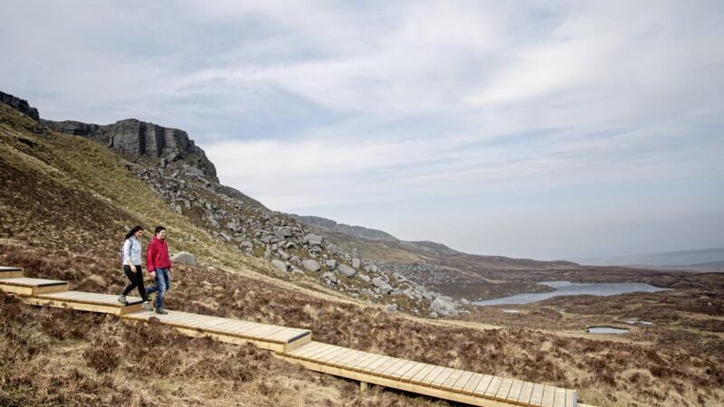
A new boardwalk protects the rare blanket bog from any erosion that would be caused by walkers in this special conservation area. The boardwalk was built through the Interreg IVA Border Uplands Project managed by the Special European Union Programmes Body and the Irish Central Border Area Network.
The trek distance is 7.4km but the walk is difficult and it could take up to six hours to complete the gravel track, boardwalks and exposed mountain path and ascent to 550 metres.
The trail to the summit of Cuilcagh crosses a number of distinct habitats, first limestone, then the extensive blanket bog and finally after a tumble of rocks the steep cliff to the summit.


If reaching the summit is not for you, venturing some way into the park using one of the walking routes will give you a taste of the beauty that can be found there. The Cuilcagh Legnagbrocky Trail is a linear route which will appeal to walkers with experience of walking hills. The route is quite isolated but showcases the scenic wilderness of Cuilcagh Mountain.
The trail meanders along a quiet farmland track before traversing a wooden boardwalk and then steady climb to the mountain face. Here a stepped boardwalk climbs through steep terrain and boulders fields before reaching the summit plateau. A rough mountain path negotiates the wild summit plateau for a few kilometres before reaching an ancient cairn [the remains of a burial mound dating from the Bronze Age, 2,500-500BC)] that stands at 666 metres above sea level.
A map of the walking route can be found at www.marblearchcavesgeopark.com/wp-content/uploads/2015/07/Cuilcagh-Legnabrocky-Trail.pdf
See more at: http://www.marblearchcavesgeopark.com/2015/07/cuilcagh-mountain-trail-open/#sthash.G9nfCa5Y.dpuf or at www.discovernorthernireland.com/Cuilcagh-Mountain-Park-Legnabrocky-Enniskillen-P8403/.
Remember to go equipped for the terrain and weather.